
")
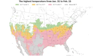
Over 200 million people across 30+ states will experience temperatures above 60°F this week, with some areas reaching 70s and even 80s.
(Source: Ben Noll / ECMWF)
As February approaches, the final days of meteorological winter give way to the early signs of spring. This transitional period often brings dramatic shifts in weather patterns, leaving many to wonder: Will winter make a comeback, or will spring arrive early? With atmospheric oscillations influencing temperature and humidity changes, February promises to be a month of contrasts. From record-breaking warmth to lingering cold spells, here’s what you need to know about the weather outlook for February.
Introduction and General Context
February marks the tail end of meteorological winter, a time when the battle between cold and warm air masses intensifies. This year, the influence of atmospheric oscillations, such as the jet stream and pressure systems, is expected to create significant weather contrasts. While some regions will experience unseasonable warmth, others may face colder-than-average conditions.
Key highlights include:
- Over 200 million people could see temperatures above 60°F.
- Approximately 140 million people may experience temperatures exceeding 70°F.
These numbers suggest a widespread shift toward spring-like conditions, but regional variations will play a significant role in shaping the month’s weather.
General Forecast for February
February is expected to be warmer than average for much of the United States, with precipitation levels hovering near normal in most areas. However, regional differences will be stark:
- Southern U.S.: Above-average temperatures are likely, with spring-like warmth dominating.
- Northwest and Canadian Border: Colder-than-average conditions are expected, particularly in the Pacific Northwest.
- Northwest and Midwest: Above-average precipitation is forecasted, with rain and snow likely.
- Texas and Southeast: Drier conditions will prevail, raising concerns about drought development.
The month will begin with record-breaking warmth, with temperatures reaching the 60s, 70s, and even 80s in some areas. Notably, no major winter storms are predicted in the short term, offering a reprieve from the harsh weather seen in January.
Precipitation and Snowfall Details
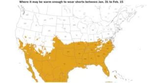
A spring-like pattern will push temperatures high enough for shorts in over 25 states this week. Unseasonable warmth continues!
(Source: Ben Noll / ECMWF)
- Gulf Coast and I-95 Corridor: Little to no significant snowfall is anticipated.
- Rocky Mountains and Northwest: These areas are most likely to see snow, particularly in higher elevations.
- Midwest and Interior Northeast: Cities like Minneapolis, Chicago, Detroit, and parts of the Northeast could experience snow, especially during colder spells.
Overall, snowfall will be limited compared to January, with warmer air masses reducing the chances of major winter storms.
Heatwaves and Atmospheric Changes
- Jet Stream Shift: A linear west-to-east flow will transport warm air from the Pacific across the country.
- Southern Winds: Warm air from the Gulf of Mexico will push northward, further boosting temperatures.
Three distinct heatwaves are expected:
- First Wave: Begins on Friday, affecting the central and eastern U.S. with temperatures in the 70s and 80s.
- Second Wave: Occurs over the weekend and into early next week, spreading warmth across the northern plains, central, and southern regions (50s to 80s).
- Third Wave: Arrives late in the week, bringing spring-like warmth to the Mid-Atlantic (70s).
Consequences and Outlook
The clash between warm and cold air will have several implications:
- Snow and Ice: Areas north of the warm-cold boundary may experience snow and freezing rain.
- Winter Recap: So far, this winter has been relatively average, with notable exceptions like the warm conditions in Phoenix and colder-than-average temperatures in the Mid-Atlantic.
- February’s Role: As the final month of meteorological winter, February will shape the overall perception of the season.
Looking ahead, meteorological spring begins on March 1, with forecasts predicting a warm and wet season, particularly around the Great Lakes.
Key Meteorological Factors
Several factors will drive February’s weather patterns:
- Atmospheric River: California will see heavy rain and mountain snow due to an atmospheric river.
- Jet Stream: A powerful jet stream will transport warm Pacific air across the country.
- Southern Winds: Warm, moist air from the Gulf of Mexico will contribute to rising temperatures.
- Snowmelt and Sun Angle: Melting snow and the increasing angle of the sun will further enhance warming trends.

A strong jet stream from the Pacific will usher in milder air, bringing warmer temperatures to the U.S. over the next week.
(Source: Ben Noll / ECMWF)
As we transition into meteorological spring, the weather patterns observed in February will set the stage for the months ahead. Whether you’re bundling up for a cold snap or enjoying an early spring day, February promises to keep us on our toes.
Here’s what to expect during the final 28 days of winter
